
Cincinnati Street Directory Address Trail
Street-by-street research in Cincinnati begins with the place, not a surname. The Hamilton County Auditor Property Search connects an address to the active tax parcel. Its summary can supply a situs address, tax-bill mailing field, legal description, and transfer lead. Those facts are related but not interchangeable. The situs tells where the parcel is, the mailing field tells where tax correspondence goes, and the legal description supplies the land language that can connect a record when street forms change. An owner field is a tax-record fact, not a full list of people associated with a building.
- Enter the house number in the Auditor Street Address form and the street base in Street Name. If the exact search fails, use a narrow nearby number range.
- Save the complete parcel ID, situs, tax year, and legal description. Most Hamilton County parcel IDs have 13 characters.
- Use the parcel map to confirm the physical location before treating a similarly named street or nearby number as a match.
- Open the transfer tab, record the conveyance number, date, price, and labeled prior and current owners, then verify the linked recorded document.
- For one named person at one exact address, use the Board of Elections form. For a dated historical household, turn to the library's address-ordered directories.
That sequence keeps ownership, recorded-party roles, and dated directory entries distinct. It also leaves a usable trail when a later search needs to be repeated.
Cincinnati Parcel Search Fields
The Auditor offers three useful routes for a Cincinnati address. Street Address accepts a number and street base. Owner searching accepts an owner, organization, or other name, while Parcel Number opens an exact parcel result. The address route is usually the soundest start because an owner-name return can be broad. When an address has no direct result, the Auditor FAQ advises a nearby range search followed by aerial imagery and parcel layers. Keep the returned parcel rather than selecting a look-alike number from a list.
| Auditor search | Fields or controls | Best use | Limit |
|---|---|---|---|
| Street Address | House # Exact/Low, House # High, Street Name | Resolve a site to an active taxable parcel | Does not list every person linked to the address |
| Owner | Owner/Organization/Other Name | Find candidate tax parcels for a known name | A name match needs parcel confirmation |
| Parcel Number | Complete parcel number | Open the parcel already identified | Retired or changed parcels may need title research |
| Transfer tab | Year, conveyance #, price, transfer date, prior/current owner | Find the recorded-document lead | A transfer row is not the deed itself |
Record which tab supplied each fact. The summary, transfer tab, and recorded document can use different dates and labels. A low price or a January 1 transfer date deserves a document check rather than a quick conclusion.
Cincinnati Street Map Confirmation
CAGIS Online is the City and County map bridge. Use its address locator, turn on Property Boundaries, and inspect the selected parcel with the Property Report or Attribute Table. CAGIS can show mapped position, parcel attributes, and surrounding geography. NearMe can test nearby mapped parcels with a 200-foot default buffer and a 1,500-foot maximum. It is useful for checking a street segment, not for making a people list from proximity.
Open the Recorder's historic deed-index page when the parcel trail reaches the older Book/Page route.
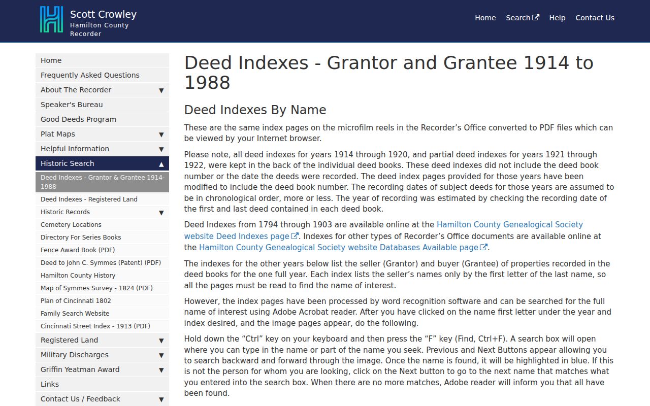
The historic index is a bridge to a dated recorded reference. Transcribe the book and page before comparing it with a current map label or parcel description.
Map geometry is not a surveyed boundary and does not establish title or current presence. If CAGIS, the Auditor, and a deed spell a street differently, retain each spelling and compare the parcel ID and legal description.
Cincinnati Deed Chain by Street
The Hamilton County Recorder Acclaim search is the document index after the parcel has been resolved. Its search modes include Name, Record Date, Date Range, Document Type, Book/Page, Document Number, Subdivision/Lot, Section Town Range, and Auditor Number. Modern name searching generally reaches records from May 31, 1988 forward. Earlier material calls for the historic grantor-grantee indexes and a careful Book/Page transcription, even though Hamilton County land-record materials reach back to 1794.
Begin at the Auditor transfer row. Search its conveyance number or Auditor number in Acclaim, then compare the document's party roles and legal description. A grantor or conveyor is the transferring party; a grantee or conveyee is the receiving party. A recorded role at a date is solid evidence of that instrument role, but it should not be converted into a claim about everyone at the street address. The image-access subscription can be useful when an image is required, but the index details should be captured first.
Note: A changed lot, acreage, or plat description is a stop sign until a split, consolidation, corrective deed, or plat explains the difference.
Cincinnati Address Records Compared
Several Cincinnati records can be searched by address, yet they answer separate questions. The table below keeps the address chain focused on the correct keeper and on what each return can actually support. A parcel number is the most stable handoff between the Auditor and Recorder. City case numbers belong to City systems, while an individual voter confirmation is a separate, exact-person check.
| Address record | Custodian | What it can show | Access route |
|---|---|---|---|
| Tax parcel and transfer lead | Hamilton County Auditor | Situs, owner and mailing fields, legal description, transfer fields | Address, owner, or parcel search |
| Parcel map and attributes | CAGIS | Mapped parcel context, property fields, and nearby geography | Locator, Property Boundaries, Property Report |
| Recorded instruments | Hamilton County Recorder | Document number, Book/Page, dates, and party roles | Acclaim or historic indexes |
| Registration confirmation | Hamilton County Board of Elections | Returned registration information for one exact submission | Name-and-address status form |
| City activity or permit case | City of Cincinnati | Address-linked case or permit status | Property Activity, maintenance, or ezTrak |
The chain is strongest when each entry includes the source URL, access date, exact address form, and identifier. That record of method makes a discrepancy visible instead of hiding it.
Cincinnati Street Activity Records
The City's address systems add a different layer. Property Activity accepts an address or record number for selected City categories. The Open Property Maintenance search offers open, closed, and all-record choices. Cincinnati ezTrak uses an exact street number, direction, street name without the suffix, suffix, optional unit or floor, or a permit/case number.
See the Cincinnati ezTrak search before entering an address in a permit or case form.
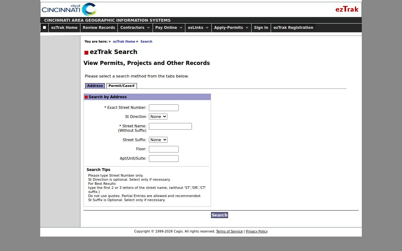
The screen is built for a precise City address or case reference. A returned permit, inspection, or maintenance record documents its own City activity, not title and not a roster of people associated with the property.
City systems may use a current address form even when an older instrument carries only a lot, subdivision, or metes-and-bounds description. In that situation, preserve the original recorded wording, resolve the modern parcel through the Auditor and CAGIS, and connect the two only when the legal description, plat, or corrective record supports it. A permit number and a Recorder document number belong in separate columns of a research log. Their similarity in date or location is not enough to make them the same record.
Save the City case identifier and status rather than trying to force it into the deed chain. Underlying records may need a focused request to the responsible department.
Cincinnati Street Numbers Before 1895
Most Cincinnati addresses changed in 1895. That local breakpoint matters whenever an old directory, deed, or family paper supplies a number that does not fit a present-day parcel search. The Cincinnati & Hamilton County Public Library house-history materials point researchers to the 1883/84 Robinson atlases and 1891 Sanborn maps for old numbers, then to 1904-and-later Sanborn maps for the new system. Match the directory year to a nearby map before carrying an address forward.
Pink Pages began in 1925, and the same address-ordered resource was called the Criss-Cross Directory by 1941. Those volumes are an effective dated street tool after the numbering issue has been checked. The Cincinnati City Directory collection details how to read the historical volumes and verify an entry against the scanned image.
Note: A matching modern street number does not establish that an older printed number identified the same parcel.
Cincinnati Street Directory Terms
Address records use short labels that can make a result look simpler than it is. These terms help keep a Cincinnati street search tied to the record's actual purpose.
- Parcel
- A tax-map unit assigned an identifier by the Auditor. It can change when land is divided or combined.
- Situs address
- The physical location used for the tax parcel. It is different from the mailing address used for tax correspondence.
- Plat
- A recorded map that lays out lots, streets, or subdivisions. It can explain a legal-description change.
- Criss-cross directory
- An address-ordered directory section that lets a researcher begin with a street and scan the printed number sequence for a particular year.
The legal description remains the best bridge when a number changed, a street has an alias, or a parcel has been altered. Preserve the original spelling as well as the normalized form used by a current portal.
Cincinnati Street Voter Confirmation
The Hamilton County Check Registration Status form is for confirming one person at one submitted address. It requires first name, last name including suffix, street number, street name, street suffix, and ZIP code. The Board instructs users to enter only the street name in that field, without a direction word or punctuation. A return can show the Board's registration information and electoral geography at the time of the search.
It is not a street-browsing tool. A no-match can reflect spelling, a suffix or number mismatch, protected status, list maintenance, or no matching registration. It does not resolve whether a tax-record owner or recorded party currently occupies the address. Retain the exact components submitted and the date of the return.
Cincinnati Street Directory Limits
No single Cincinnati street record identifies everyone connected to a building. The Auditor's owner and mailing fields have tax purposes. A Recorder result identifies recorded parties. CAGIS supplies map and parcel context. A historical directory reports what its publisher printed in that year. Driver and motor-vehicle personal information is not a general address-search fallback, and protected records can be absent from ordinary public results. Treat a nonmatch as a limit of the selected record, not a conclusion about a person.
Lawful use. Use Cincinnati address records for personal, lawful research and verification. Do not use an address, parcel, directory, or map result to stalk, harass, intimidate, or harm anyone.
When sources conflict after the parcel ID, legal description, transfer date, and old or current street form have been checked, preserve the conflict and ask the City or Recorder for the narrowly identified record. Keep the returned parcel ID, document number, or case number with that request. A careful unresolved note is more reliable than joining two records because the street name looks familiar.